
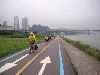
This Map gives some indication of areas to ride.
Red = dedicated cycle path 빨간색 = 자전거 전용
Green = shared 녹색 = 자전거 보행 자겹용
The red vertical line running N-S is the Jungangchon
mentioned in the article below Cycling in Seoul
The map is apparently available from 'the information booth in
여의도 공원(Yeouido Park) ,on the opposite side of the park from
the LG Twin Towers', though I have yet to confirm this.
For a different route see the excellent 'Heart Course'
google map on the right hand under links.


No comments:
Post a Comment